
arqr
// key words
augmented reality [AR]
navigational tools
way-finding
quick response code [QR]
mobility
smart city

Given the aftermath of the pandemic, our cohort was unable to attend the 'Go Global' module. IDE alumnus [pre-Covid] previously travelled to a different country for this module, outside of the UK. Since we were the first cohort to return after remote learning, this module changed to 'Go Local', aka - im[P]act. Our cohort was partnered with Westminster City Council and we were tasked with creating creative and innovative solutions to help accelerate the transition to a more sustainable future from a Smart City perspective.
During my time in service, I took a master navigational course [pre Sergeants / Senior Sergeants Academy]. We were given a map, an azimuth compass, and several coordinates. We needed to map out the route and memorise them by night's fall. We were instructed not to use the maps during the journey; the only instrument available was a compass. When we reached the coordinates, we were tasked with documenting the scenery for proof. To calculate distance, I sometimes would pick up a number of stones. Every 62nd step of mine measured 100 meters and I would drop a stone. The remaining stones identified and reminded me of how many more [100m] are necessary before changing the azimuth of my direction and proceeding through another path.
Our biosphere is now engulfed by a technosphere. Everything organic is now pretty much wrapped in the web of technology. We rely on our phones to navigate us almost anywhere. There is no need for stones within the civilian realm.
Population is growing, resulting in higher density per capita - challenging our current methods for transportation and delivery. With Westminster's foresight, and, our collective efforts and interests, our team [M1] was led to think of solutions that could drive local economy and improve pedestrian fluidity in the Strand Aldwych area of central London.
research


We initially set out to the area for observations and conducted multiple interviews.
// pedestrians -
Our observations from the walking experience included: Construction creates "choke points" where walking pace slows and people struggle to get by. Construction and road congestion make the pedestrian experience negative. Composition and aims of crowd differ by time of day, block-by-block.
// transit - Our observation of the transit revealed: Students don’t feel safe biking in the area. Pedestrians perceive that cycle lanes go unused. Bus frequency and slow speed makes getting around difficult. “Only the wealthy can afford ubers or private cars in this zone. The rest of us have to walk, bus, or risk riding”
// insights - The Strand feels like a street that pushes you through and out rather than inviting you to stay and explore. “Discovering” something delightful isn't just enjoyable for tourists; locals and commuters also feel positive when their bland routine gets positively shaken up. It's unlikely you would happen upon local attractions and open areas without prior knowledge or a pre-set destination in mind.
// ar - Augmented reality allows for powerful and intuitive solutions in navigation. By showing virtual guides in physical space through the view of a smartphone or headset, users can be directed point to point more naturally than by comparing a map to their immediate surroundings.
// ar - The mobile AR market size in 2021 is 8.9 [bil. USD]. With an approximated 810 million active users.


// QR - QR code scans quadrupled in 2022. The flexible nature of QR technology has led to many innovations that streamlined daily transactions, which is why enterprises now use them to upgrade their services.
// QR - QR codes are frequently used to track information about products in a supply chain and – because many smartphones have built-in QR readers – they are often used in marketing and advertising campaigns.
Our intervention would need to be in the context of usage and user experience. Given my experience with id0d I was eager to see how innovative we could get by incorporating qr technology with ar navigation. "They could be markers for navigating the city, like the stones", I thought. What information/experience can we provide the pedestrians with to better assist in their way-finding while improving fluid navigation through the dense area?
process
The M1 team reconvened after the initial interviews and observations. There we discovered three common areas of interest:
// discovery - [a]Gamifying discovery of businesses or historical monuments. [b]Guiding people to explore beyond the main road and to discover local attractions. [c]Disrupting routine in order to improve quality of life.
// refuge - [a]From negative environmental stimuli (noise, air pollution, traffic). [b]From congestion. [c]To facilitate social interaction. [d]When it's wet out.
// [re]routing - [a]Creating different routes using visual cues. [b]Improve safety with better cues for how to move through the space. [c]Draw people in from areas that feel disconnected.
How might we improve discovery? Of local gems, historical detail, and of places to pause.


We then drew up some sketches and conducted a series of rough prototypes that explored pedestrian mobility of the area and asked ourselves, how might we create a hybrid digi-physical experience of the Strand-Aldwych that enables personalised discovery and navigation of theneighbourhood? and continued to embed AR navigational tools to the web-based platform we were developing.
// learnings - People were interested in AR-augmented navigation to discover routes and attractions. Google Maps AR navigation is not commonly used.

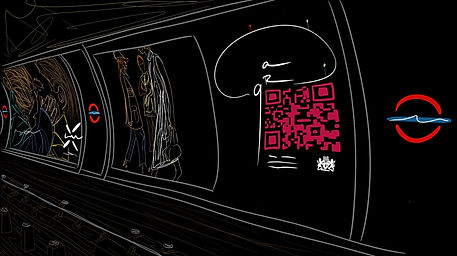
We printed a deck of posters including QR codes, and disbursed them throughout the strand. The codes were used to direct the users to the web address we were developing.
// learnings - received very positive feedback. People liked the QR codes as a method of making the technology more accessible and convenient. "Yeah, I would use that. I expect that's the future, right?"
our initial research uncovered a key problem space: people move through and out of the area, instead of lingering and discovering things.
outcome


// web - A web based AR navigational system that tailors personalised discovery routes to find and explore local attractions. arqr suggests more scenic routes, faster routes, and attractions along the way. This helps disperse congestion in the crowded city and gives local business an opportunity to be discovered by tourists, and allows locals to more freely roam the area. The user experience and interface are easy and fun.

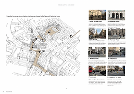
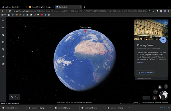
// ux - In our user group scenario, a few friends decided it's a lovely day to visit the Courtauld Gallery on the Strand. Upon arrival, they notice a series of cues disbursed throughout the Charring Cross Station. Once they've exited the station and have reached the strand, additional cues are visible, complimented by behavioural triggers like "take the quiet route" or take the "scenic route". The users are directed to the arqr webpage by scanning the qr code.


// ui - The AR display is then prompted, giving the users a sense of direction, and, recommendations of the area that would otherwise be missed, via [re]routing them through undiscovered gems of the area. Since these infrequent visitors are in no rush to the Courtauld, they decide on having lunch at one of the 4 recommendations listed, en route to their destination. They prefer to take the scenic route.

// arqr - A personalised AR experience for discovery and navigation. With our QR-enabled technology, there’s no need to waste time downloading an app. Our web-based platform allows users to easily find local attractions, oddities, and happenings hidden just out of view. With arqr, users can choose their own adventure and experience the city like never before.
// very good - Good research insights gained on opportunity space. Good professional presentation. Clear concept created. Nice approach to prototyping and 'wild' testing. Good reflections on challenges faced in user testing. However not clear on the general attitude to the value of the concept. Maybe focused too quickly on design details before making sure that the concept really works. -Professor Gareth Loudon [Head of Programme, RCA]
See the strand through new lens - using QR codes instead of AR as people tend to not use AR-related apps. Good differentiation between macro - meso - micro level. Insights during test run: 2-4 scanning each after 1 day in the strand. Well done doing this real-world user testing! Historical integration with King's College data - great idea and might add a lot of value to the original project with WCC. Some good ideas into branding and WCC-related implications. QR code put in a Strand-location, that's a nice experiment and great to see that you can use it to quantify results. -Dr. Bjorn Sommer
It would have been useful to summarise the volume/types of primary research in the area you had conducted. Great point about exploring the barriers to AR adoption. It would be worth having a look at the Pluggy.eu project worked on by the Dyson School - and the audio/soundscape opportunities for location-linked AR experiences. -Dr. Stephen Green [Head of Programme, ICL]
evaluation


// learnings - QR codes received ~2-4 scans each after 1 day on the Strand
- Difficult to disrupt existing behaviour (e.g., looking at phone while walking, ignoring surrounding advertisements)
- Success of AR is equally about the sense of wonder/novelty as it is about the utility
- Environmental cues are a good way to engage people, but the behavioural trigger and setting is crucial.
im[P]act
// micro - Individual visitors discover elements of the neighborhood they wouldn't have otherwise found. Pedestrian experience is more spontaneous/joyful.
// meso - 'Vibe' of place changes from 'through and out' to stay and discover. Repeat visits are encouraged.
// macro - Local businesses experience positive economic effects. Planned 'cultural routes' become reality.

Considering the master navigational course I
took in the military, along with my extensive navigational experiences around the world, I wonder how technology like this can be implemented for combat troops. For example, I recall three points: initial,
mid and endpoint along the journey. I knew I had arrived at the correct destination given the description of an object. I was requested to photograph and present my findings. Can we
gamify this experience for soldiers? How will this kind of tech be used on the battlefield? Although
civilian application and usage is evident, I am curious to
see where further development of this will lead in terms
of military or
municipalities usage.
// next steps and potential rollout strategy -
Route planning & stakeholder research:
- location scouting
- interviews with locals to assemble shortlist of destinations
- outreach to key business owners to involve with route planning and
any incentives
- collaboration with governing entities to secure required permissions
1 month beta rollout, with view to test:
- messaging [to entice entry].
- embodiment - including physical QR sculptures, mosaics, murals, etc.
- additional AR features.
- additional "choose your own adventure" features.
Refresh, with additional testing, including:
- incorporating other 'gems' [e.g. exclusive events, fashion collabs/drops, popup restaurant access].
- potential to scale to app version
- integration with historical AR information layer being led by
Kings College.
- integration of incentives or other gamification strategy
[via tokens or rewards].